The figures :
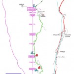
26 kilometers – 1300 meters of elevation gain – 500 meters of descent.
Only a 6% average slope. (8.5% up to Orisson, 5% afterwards)
It takes between 7 and 8 hours to get to Roncesvalles, with a pack of 8 to 12 kgs. A fit person will do it in 5 ¾ hours.
SO, YOU DO NOT HAVE TO LEAVE THE HOSTEL AT NIGHT !
Clic on the map below to enlarge it
The rise :
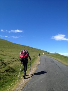
 18 kms of a beautiful but paved road ! The former route of the GR65 is not signposted any more!
There are only three steep tretches of a few hundred meters each: just out of the village, below the hostel Huntto, and between Huntto and Orisson (remember to take the shortcut). After 7 kms, you will have climbed almost half the altitude !
Food and water supplies in Huntto and Orisson (5 and 7 kms).
At the Thibaut cross, turn off the road and take the small path climbing to the right and passing very shortly a rocky shoulder (shepherd’s shelter below right). Spanish border. Small path that winds through the forest.Drinking fountain (km 20).
Km 22: shelter with a fireplace, then climb to the Lepoeder pass on a wide gravel road.
The descent :
When you get to Lepoeder pass (km 23), the path meets a small asphalt road. Turn right and go down about fifty meters. You meet a set of road signs on a tall pole. There are 2 solutions available:

![IMG_4822 [Résolution de l'écran]](https://www.ultreia64.fr/wp-content/uploads/2013/04/IMG_4822-Résolution-de-lécran-225x300.jpg)